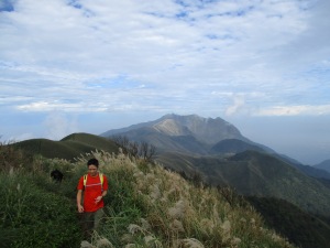
Introduction to Hiking in Yangmingshan
As you probably already know, Yangmingshan is a small national park located between Taipei city and the north coast, some of it within the actual city limits of Taipei. The park is centered around Qixing, the highest mountain in the park.
The park is full of hiking trails and other features such as waterfalls. Some areas of the park are very popular and can be crowded on weekends. But there generally aren’t a lot of people on the trails away from the main areas, and some areas are off-limits.
Getting to the park is easy. There are several buses that go from Jiantan MRT station to the Yamgingshan bus station/Starbucks. The Red 5 bus is the most frequent, coming about every 10 to 15 minutes. Bus Small (Xiao) 15 also goes from the MRT station to eastern side of the park, but does not go to the Yangmingshan bus station.
From the Yangmingshan bus station, there is a shuttle bus (number 108) that makes a clockwise loop through the park around the slopes of Qixing. However, this bus is infrequent, small, and jam-packed. If you are in the eastern side of the park you may have to wait up to 90 minutes to get on the bus. Some buses make the complete loop and others only go to the Erziping stop (二子坪) then return to the bus terminal.
I have several hikes listed here that will take you through the highlights of the park without having to use the shuttle bus to get off the mountain. Please click on the links below for more information on hiking in Yangmingshan.
Mt Zhongzheng: start from the Zhuzhi farms area, hike to the Zhongzheng Observation Deck on the southern slope of Datun, then descend to Beitou
https://bikehiketaipei.wordpress.com/mt-zhongzheng/
Datun: hike over Datun, the second highest peak in the park, to the Erziping ponds, then descend down the mountain to Beitou with a side trip to a volcanic caldera.
https://bikehiketaipei.wordpress.com/datun/
Qixing: hike over the highest peak in the park.
https://bikehiketaipei.wordpress.com/qixing/
south Yangmingshan/Tienmu: start from Yangming Park, which has gardens and ponds plus two waterfalls, hike around the slopes of Mt Shamao, up a secluded gorge to another waterfall, then finish by taking the famous Tienmu Trail down to Tienmu.
https://bikehiketaipei.wordpress.com/south-yanmingshantienmu/
Qingtiangang: hike up a stream passing a waterfall to the popular cow meadow, take a circular trail over the peak of Mt Zhugao, then descend on the fish trail.
https://bikehiketaipei.wordpress.com/east-yanmingshan/
Mt. Shiti: a long ridge hike through the far eastern side of the park
https://bikehiketaipei.wordpress.com/mt-shiti/
Pingding: hiking along a stream on rough dirt trails on the southern slopes of the park
https://bikehiketaipei.wordpress.com/pingding/
Map of Yangmingshan trails


